The Essex Historical Society and Shipbuilding Museum (EHSSM), is a unique institution nestled along the…
Nanotags: Understanding large landscape connections using nano-technology
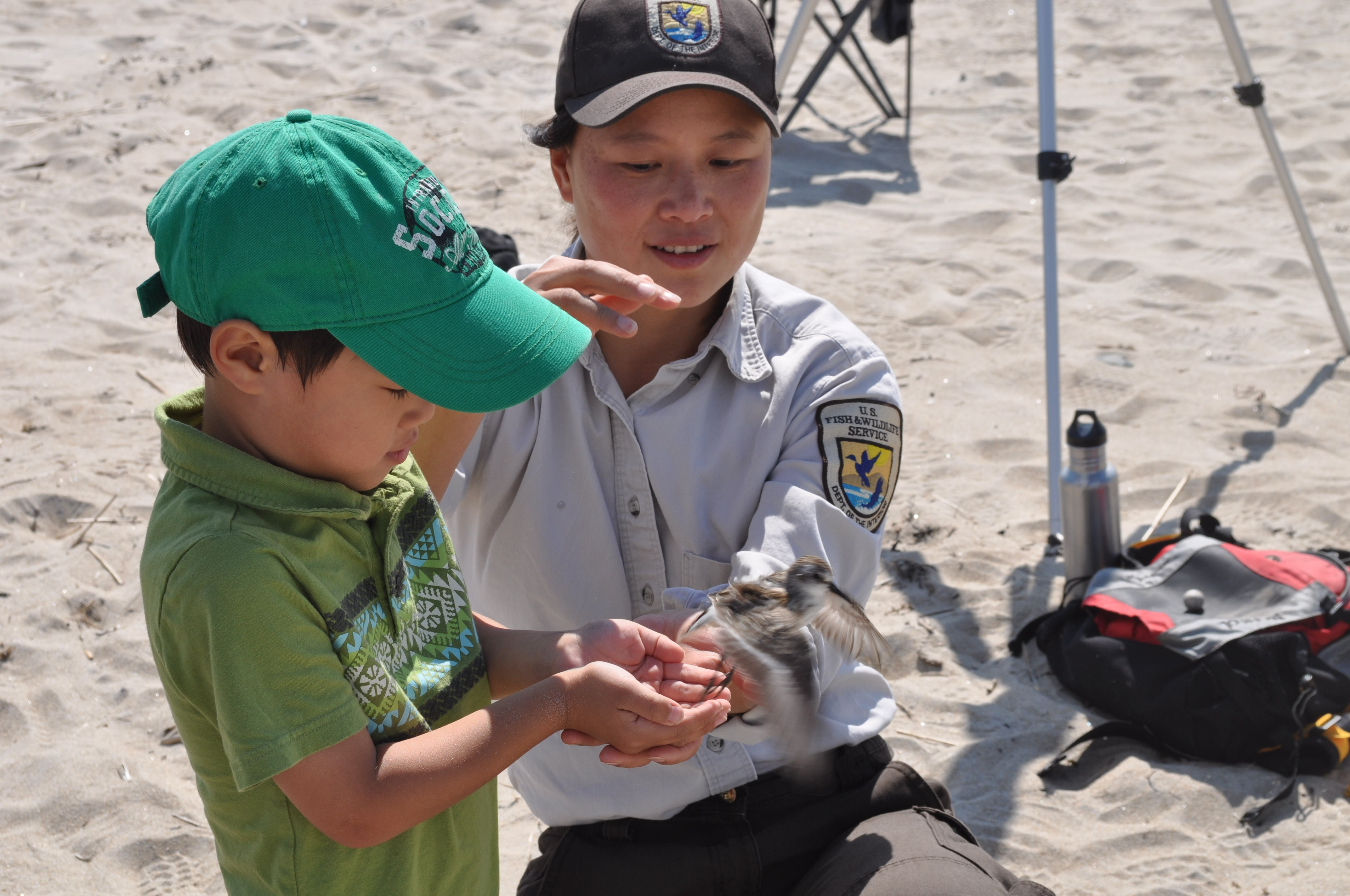
by Nancy Pau, Wildlife Biologist, Parker River NWR
Plum Island and Parker River National Wildlife Refuge is known for its diverse and abundant birds, and as a top birding destination. This aligns closely with our establishing mandate, which is to manage the refuge “for use as an inviolate sanctuary,… for migratory birds”. In fact, Parker River NWR was designed as one stepping stone in a nation-wide ”network of lands and waters managed for the conservation of fish, wildlife, and plants resources within the United States for the benefit of present and future generations of Americans”.
As a staff biologist, the greatest challenge in meeting this mandate is that most of our wildlife are migratory, and spend only a portion of their annual cycle within our boundaries. We have tried to address some of this through local and regional collaborations like the Great Marsh Coalition and the PIE Rivers partnership. In order to meet full life-cycle needs of our wildlife species, however, we needed more information about how the Refuge is connected within the larger Atlantic flyway.
In recent years, advances in technology (such as satellite GPS and geolocators) have allowed scientists to track animals across continents, advancing our understanding of their full life cycle needs and ability to identify threats and vulnerabilities throughout their range. However, this technology is expensive and has been limited to larger wildlife species. Since 2013, the Refuge has been working with a new technology which makes tracking of the smallest species feasible and affordable on a landscape scale.
Nanotags are the very light-weight coded telemetry tags developed by Lotek, Inc. In contrast to traditional telemetry tags that broadcast on unique radio frequencies, coded tags emit signals in such a way that computers can differentiate thousands of unique combinations. This enables thousands of animals to be monitored simultaneously on the same frequency, making automated detection feasible, and drastically reducing the cost of telemetry studies. Dr. Phil Taylor of Acadia University saw the potential for large scale collaboration of a monitoring network, and has helped to coordinate building and deployment of over 400 automated detection towers that cover Canada to South America. This expanding monitoring network allows researchers to ask questions on a flyway scale, knowing that they will be able to track any tagged animals that migrate through the network.
There is still much work to be done in developing this monitoring network strategically. In these early pilot years, we have been as focused on testing the technology as we have been on learning about migration and movement of our wildlife species. Even still, we have learned quite a bit more about our highest priority species that use our Refuge (and the Great Marsh). Below, we briefly describe what we have learned, with some conjectures, and some management implications and next steps.
Shorebirds
Using semipalmated sandpipers as surrogates, the nanotag data is indicating that shorebirds are longer-distance fliers than previously thought. Sandpipers stop for an average of 2-3 weeks at the Refuge to refuel, with some staying over 1 month. The majority of the tagged birds flew in an easterly or southeasterly direction when leaving Plum Island, and were not detected by towers in Cape Cod and Rhode Island. Combined with re-sighting of color-banded shorebirds and geolocator work on willets, we believe the shorebirds leaving the Great Marsh may be making the 4-day non-stop flight over the ocean ( >2,500 miles) to land in Surname and French Guinea, ultimately wintering in northern Brazil. From our Canadian research partners, we also learned the shorebirds that are tagged in Bay of Fundy, James Bay, and southern breeding grounds like Coats Island (top of Hudson Bay) are mainly making direct flights to South America, rather than making shorter hops down the east coast.
The long over-ocean flight of shorebirds from breeding ground to wintering ground with only a few stopovers stressed the importance of areas that get large shorebird concentrations during migration, such as the Great Marsh. For the Refuge, this new information highlights the importance of providing un-interrupted resting and foraging habitat for these tiny birds while they are here. Our preliminary data shows that birds that stay longer tend to make more direct flights (over ocean), while those that have a shorter stopover fly closer to the coast, and stop at other sites. We also learned that shorebird are relatively mobile and use a variety of habitats during their stay, from beach to salt marsh to impoundments.
Salt marsh sparrows
Salt marsh sparrows are unique in that they spent their entire life in salt marshes and have their entire breeding and wintering range in the eastern U.S. They are also the poster child for sea level rise as they build their nest and raise their young in salt marshes in between monthly flooding tides. In the last decade, the Refuge has been working with partners to learn more about the sparrow’s breeding behavior and population dynamics. With the expanding nanotag tower network, we finally were able to start investigating the connection among breeding, migratory, and wintering habitats in order to develop better conservation strategies for this highly imperiled species. In the first year of the pilot, we were able to track more than 60% of the birds as they migrated along the coast from ME, MA, and RI down to Virginia. An animation of the s sparrow’s migration can be viewed at: http://motus.org/data/demo/saltmarshSparrows2015.html
In the coming weeks, we will be deploying additional tags on salt marsh sparrows in Maine, Massachusetts, and Rhode Island, to learn more about timing of migration and migratory routes of this sparrow during their fall migration. We also deployed tags on sparrows in South Carolina this spring to track their northward migration. Having a better understanding of where our sparrows migrate through and winter will allow us to address all threats to their survival, and better understand local population trends that we’re seeing in the Great Marsh.
Bats
Bats are quickly becoming a priority for conservation, due largely to two emergent threats that have dire consequences to their survival. White nose syndrome is an introduced fungus that is having devastating effects on our bat populations, particularly the two most abundant bats in the eastern U.S.: the little brown bat and the northern long-eared bat. Large wind energy development potentially has population-level impacts on migrating bats, particularly along mountain ridges and in coastal areas. These landscape-level questions are expensive and difficult to research, particularly for a group that has received little research funding in the past.
While we have not coordinated large-scale study for bats as we have for the above species, we were able to work with partners to deploy a few pilot tags and learned a few things. One thing we learned was that bats may be active later in the season than previously believed. By tracking bat movement 24/7, we learned that migratory bats, like red bats, are making migratory movements later than anticipated and that local hibernating bats, like big brown bats, will emerge well into October when weather is favorable. Working with bats has been challenging as they seem especially apt at removing the nanotags; however, the technology shows promise in being able to track red bats that migrate along the coast. This August and September, red bats and big brown bats were tagged with nanotags, and we look forward to seeing what we learn from the data.
We still have more research to do to confirm some of the hypotheses speculated above. However, this new technology has provided some surprising new data that challenges our scientific understanding of migration. At a time when our wildlife is under the greatest threat from a changing environment, it’s nice to have a new tool in the conservation toolbox that can enhance our understanding of wildlife species and how to conserve them.
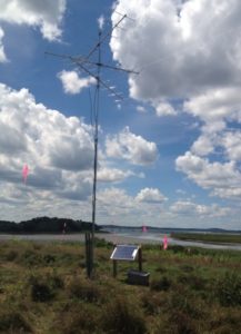 Nanotag towers, like these, are deployed from Canada to South America by a network of researchers. These automated towers record any animal that flies within 12-15 km of the tower. See Motus.org for more info.
Related Posts


This Post Has 0 Comments