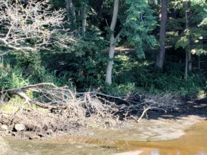
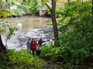
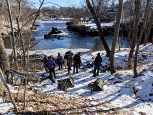
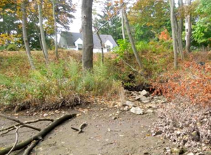
Ipswich River Resiliency Project team members examine several areas of coastal bank erosion along the Ipswich Riverwalk trail near Town Hall and along Water Street near the Green Street bridge.
NEW IN 2021: Check out our recently completed Story Map to learn more about the background and current status of the project, including our short film The Story of Ipswich!
As part of this multi-year resiliency project being led by the Town of Ipswich, Ipswich River Watershed Association and Ipswich Community Access Media are launching a new video series about coastal resiliency and community leadership.
The Massachusetts Office of Coastal Zone Management (CZM) has awarded a coastal resilience grant to the Town of Ipswich. The grant will address critical infrastructure and planning needs along the Ipswich River. The project includes vegetative improvements to stabilize the riverbank, upgrades to the sewage infrastructure, and videos and an interactive story map focused on the nearby Riverwalk trail.
The video series is part of Phase III of this project. For background and prior project updates, read on below. To download or view the full January 2021 press release, click here.
Background
The Ipswich River Bank Resiliency Project started way back in 2016. The Town of Ipswich and its partner, Ipswich River Watershed Association, were awarded a 2016 Coastal Resiliency Grant from the Massachusetts Office of Coastal Zone Management. Initial funds supported a one-year pilot project to identify vulnerable areas along the Ipswich River between the Ipswich Mills dam downtown to the Town Wharf on Water Street. A team of coastal geologists and engineers were hired by the town to inspect erosion and other areas that have deteriorated due to both tidal and inland flooding. The focus of the study was those areas of the river bank adjacent to town infrastructure such as water, sewer, and roads.
The project looks at long-term impacts of climate change, including sea level rise and heavier storms. Recommended improvements focus on nature-based solutions, or green infrastructure, to fight erosion and provide long-term bank stabilization. The project also includes measures to educate residents on ways their behavior and use of the area impact the health and stability of the coastal bank.
Project partners include the Town of Ipswich, Ipswich River Watershed Association, Horsley Witten Group, and Coneco Engineers.
Past Updates
June 2019 Update
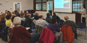
Ipswich residents, interested PIE-Rivers Partners, and the general public were invited to a meeting to learn about the Ipswich Riverbank Resiliency Project and the Argilla Road Flood Mitigation Project on June 10, 2019, at 6:30pm in Ipswich Town Hall, Room C. Ipswich municipal staff and their partners presented on the impacts of climate-driven precipitation and coastal storms on our natural resources and human infrastructure, and described the details of these two projects.
Workshop flyer here.
Presentation slides here.
Story map about the Argilla Road project here.
April 2019 Update
Over the winter and spring of 2019, the Horsley Witten Group, Inc. (HW) completed the Environmental Notification Form (ENF) for the proposed Ipswich Coastal Bank Restoration and Resiliency Project on behalf of the Town of Ipswich. The goals of the Project are to apply nature-based, sustainable shoreline techniques, slope stabilization, and stormwater improvements to address a section of currently eroding and undercut coastal bank along the Ipswich River. Implementation of this restoration project will require the Town to obtain approvals or permits from various regulatory agencies, including:
(1) Review under Massachusetts Environmental Policy Act through an ENF;
(2) Approval under the Massachusetts Wetlands Protection via an Order of Conditions from the Ipswich Conservation Commission;
(3) Approval under the Massachusetts Department of Environmental Protection (MassDEP) Chapter 91 Waterways Regulations (310 CMR 9.00);
(4) Review under Massachusetts Coastal Zone Management for federal consistency;
(5) Approval through a U.S. Army Corps of Engineers Section 404 General Permit.
The project will generally involve:
• Replacing existing stormwater drainage pipes and outfalls that are currently undercutting the coastal bank;
• Improving up gradient stormwater infrastructure and right-of-way; and
• Stabilizing the eroded and undercut coastal bank using living shoreline techniques.
For more information about the project including detailed design plans, download the Environmental
Notification Form here.
 January 2019 Update
On Wednesday, January 23rd the Town of Ipswich led a public meeting to discuss the River Resiliency Project and nature-based solutions being implemented to mitigate flooding, erosion and stormwater pollution. Coverage. Brochure on Coastal Resource Area Protection.
Topics of discussion included:
o Impacts from climate change and sea-level rise on critical infrastructure (water, sewer, power, roads) and other community resources.
o Importance of protecting natural resources to better protect public and private property.
o Plans to use nature-based solutions to restore an area of severely eroded bank at the Shurcliff Riverwalk and County Street Bridge.
o Overview of other town projects protecting critical infrastructure and natural resources, and what residents can do.
September 2018 Update
Phase II of the Ipswich River Coastal Resiliency and Bank Stabilization Project kicked off in September 2018. With funding support from the Massachusetts Office of Coastal Zone Management’s 2018 Coastal Resiliency Grant program, the Town of Ipswich and partners developed permit-ready plans to stabilize one heavily eroded section of the coastal bank. The project will help protect a vulnerable sewer pipe outfall, as well as a heavily used section of the recreational Riverwalk trail behind the Ipswich Town Hall, near the County Street Bridge. Using living shoreline techniques, this green infrastructure project demonstrates one visible way our watershed communities are addressing and responding to climate impacts.
Final Phase I Project Update – June 2017
Phase 1 of the Ipswich Riverbank Resiliency Project wrapped up in June, 2017. Along with outreach initiatives mentioned below, the team created educational signage about erosion and stormwater issues. Signs were installed in two locations, one along the Riverwalk trail and the other on Water Street.
The team also completed a project permitting matrix (see links below), as well as 30% design plans and cost estimates for two Areas of Concern (AOC) chosen as highest priority locations. Area of Concern 1C runs along Water Street near the Green Street intersection. Area of Concern 4 is at a sewer outfall at the other end near County Street.
The Town of Ipswich continued searching for funding to finish permitting and move towards final design plans. The ultimate goal is to implement the green infrastructure solutions developed for AOC4 near the sewer outfall.
May 2017 Update
Ipswich mailed informational pamphlets talking about the River Bank Project to residents living near the downtown stretch. Residents were invited to attend an Public Informational Meeting on May 24, 2017, where Town Planners and partners presented findings to more than 40 Ipswich residents.
- Meeting Invitation
- Project Informational Pamphlet
- News
- Presentation Slides
- More slides from Ipswich High School presentation on May 19, 2017.
April 2017 Update
In February and March, Contractors Horsley-Witten and Coneco completed further analyses of the six Areas of Concern (AOC) along the northern bank of the Ipswich River in downtown Ipswich, MA. These AOCs are areas where bank erosion is occurring, as described in the January 2017 reports posted above. The reports below describe proposed bank stabilization projects and stormwater improvement projects for those six AOCs. The reports were completed to provide a basis for the Town and the project Steering Committee to prioritize the AOCs and proposed projects, and select which AOCs to focus on for further design as part of this project.
- Ipswich River Bank Project – Bank Restoration Recommendations – Final Report Task 3
- Ipswich River Bank Project – Bank Restoration Recommendations – Final Report Task 3 Appendix
- Ipswich River Bank Project – Stormwater Improvement Recommendations – Final Report Task 3
February 2017 Update
A letter describing the project was sent from former Ipswich Conservation Administrator Alicia Geilen to residents of the project area neighborhood on February 16, 2017.
January 2017 Update
Contractors Horsley Witten and Coneco completed assessments of the Ipswich River bank on municipal land between the Ipswich Mills dam and Town Wharf. To view their findings, click on the below reports:
- Assessment of Ipswich Coastal Bank – Horsley Witten report Jan 2017
- Horsley Witten Appendix A Assessments
- Assessment of Stormwater Structures along Ipswich Coastal Bank – Coneco report Jan 17
For more information, contact:
Kristen Grubbs, Ipswich Conservation Administrator, kristeng@ipswichma.gov, 978-356-6661
Patrick Lynch, Planner, Ipswich River Watershed Association, plynch@ipswichriver.org, 978-412-8200